Augmented Reality technology must be nearing the gap – at least that’s what comes to mind when you discover two articles about the latest developments around the technology on the front page of Germany’s most important online news magazin, Spiegel Online.
Both articles are in German, but Google Translate results will get the core ideas across. The first article provides an overview of different use cases that can already be served by the technology. The author of the first article notes that what is still missing, is an application, which pulls things together to offer a one stop shop for augmented reality search, exploration and discovery. The second article looks at some applications like Mobeedo and Layar in more detail.
But it was a third article about the disruption in the Navigation Systems market that Google Maps Navigation and low-cost iPhone navigation apps like Skobbler have kicked off recently, which got me thinking about augmented reality in a different way – even though that third article does not actually cover augmented reality.
The authors argue that Google’s camera equipped Street View Cars are in fact Trojan horses, since capturing the images is just one aspect of the map data collection and processing that is actually happening behind the scenes and under the hood of the Google Street View cars. As the 360 virtual reality mapping mission progresses, each kilometre of geodata generates more information and less privacy. But how is this related to Augmented Reality?
Google continues to build the most impressive digital earth application out there – Google Earth. Thinking to the end, it may be difficult to distinguish the real view that you see when you are actually out there, exploring, from the the virtual reality view, generated by geodata. The next best thing to being there. So what is the difference between…
- …pointing your iPhone or Android device around and looking at the augmented reality camera view that displays overlayed objects in reality and…
- …virtually moving around a 360 virtual reality world, where additional information can also be overlaid?
Time. Obviously, Google’s virtual world cannot provide a real time view any time soon. Although first steps in that direction have been made by research groups, even Google consider it creepy and probably also a little bit too difficult – at least at the moment.
Screenshot taken from Google Geo Developers Blog
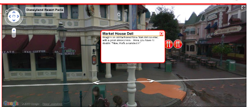
But if you don’t mind the time gap between now and when the images were taken, then Mapsicle, a cool new Street View library developed by New Zealand company ProjectX, will enable you to create and experience armchair augmented reality. Virtual tours that link up panoramic images and overlay information have been around for quite a while, especially in the real estate industry. But with Google Street View providing the ultimate roadtrip virtual tour and easy tools to overlay information and add links, like Mapsicle, things are taken to a new level. Mapsicle was even featured on the Google Lat Long blog and we may expect that there is more cool stuff ahead with this project. Why?
Because it is very cool to have a real world interface that complements the map as a way to search, explore and discover information as if being there. State of the art augmented reality apps enable you to check out what’s around your current position and put it in context of what you can see in a certain direction – soon we’ll find out what’s around the corner in the same photorealistic way – but without having to walk there if it is not worth it. We can virtually explore and use augmented virtual reality as an intuitive real world metaphor for search, exploration and discovery.